
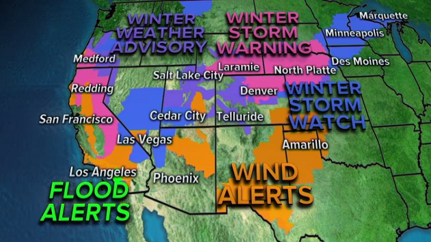
 ABC News(LOS ANGELES) — A turbulent weather pattern is about to take shape over the U.S. just as we head into the Holiday Week with 2 high impact storms that will bring dangerous weather to much of the country. Over 35 million people are under a weather alert this morning from California to Michigan — an area covering nearly half the western United States including major cities and transportation hubs like Los Angeles, San Francisco, Las Vegas, Denver, and Minneapolis.
A storm will begin to organize and deepen in the Rockies late Monday. The storm then moves eastward on Tuesday into the north central plains and into the upper Midwest on Wednesday.
The first major storm is likely to bring locally over 12 inches of snow to parts of Colorado and Wyoming and locally 6 inches or more of snow through the north-central plains into parts of the upper Midwest. Regardless of snow totals, blowing snow will limit visibility and make driving very dangerous.
Meanwhile another storm is sneaking in behind it along the west coast for Tuesday and Wednesday. The second major storm will bring major winter impacts to a large part of the west coast with locally over 2 feet in some of the mountains and possible flash flooding in southern California. This same storm will also move into the Rockies and travel through the central U.S. on Thanksgiving and into the extended holiday weekend.
The first storm develops late today and really organizes in the early morning hours Tuesday across the high plains of Colorado and Wyoming. Periods of heavy snow will occur in the Denver metro area Monday night and Tuesday.
Difficult travel is expected and mountain travel may be nearly impossible. The Denver metro area could see 8 to 14 inches of snow with more snow possible in the foothills.
By later Tuesday and into early Wednesday the storm will slide into the upper Midwest. A swath of heavy snow will move across parts of Nebraska, South Dakota and into Minnesota and Iowa. Locally heavy snow at times could cause difficult travel on interstates in this region.
Additionally, strong storms are likely to develop along the cold front that extends from the Great Lakes down to the Gulf Coast. There could be some severe storms that are in the line that develops, especially closer to the Tennessee and Gulf coast.
By Wednesday, a wide swath from Colorado to Michigan could see over 6 inches of snow, with the greatest amounts along the Colorado and Wyoming border where totals will exceed 1 foot.
The second storm will move into the west coast late on Tuesday. The storm will initially bring an area of heavy snow to northern California and much of Oregon.
By Wednesday, the storm will bring snow down through the Sierras and heavy rain in likely to move into Southern California. Locally over 2 feet of snow will accumulate in the mountains and locally 1 to 2 inches of snow will fall in Southern California.
This will make Wednesday Holiday travel very dangerous on I-5, I-15 and I-80.
This storm is slated to move in a similar fashion to the first storm and hit Colorado, the central Plains and upper Midwest as we head towards Thanksgiving and Black Friday.
Copyright © 2019, ABC Radio. All rights reserved.