
 ABC News(NEW YORK) — The National Weather Service is still assessing the tornado damage in Davidson, Wilson, and Smith counties in Tennessee Wednesday morning after the area was hit with severe weather.
The highest winds discovered by NWS meteorologists with these tornadoes were in Donelson, which registered an EF-3 tornado with wind speeds of 160-165 mph. In Mt. Juliet, there was EF-3 twister with 155-160 mph speeds.
Storms there killed at least 24 people and authorities said 38 people remain unaccounted for.
In East Nashville and Five Points, an EF-3 tornado tracked at 136-140 mph and in Germantown/North Nashville, there was an EF-2 with speeds of 125 mph.
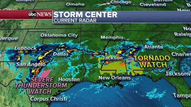
Wednesday morning, more severe weather is developing in the South with tornadoes possible from Texas to Florida.
There is a tornado watch from Louisiana to the Florida panhandle Wednesday morning. There is also a severe thunderstorm watch in central Texas, where winds could be higher than 60 mph.
Wednesday afternoon and evening, a new low-pressure system will move out of Texas and will shift east along the Gulf Coast and will bring more severe storms from Louisiana to Georgia and Florida’s panhandle.
A severe storm threat moves into Florida and southern Georgia Thursday, from Tallahassee, Florida, to Jacksonville and Savannah, Georgia. Tornadoes will be possible again with this storm.
In addition to tornado threats and damaging winds, there is a flash flooding threat for the South from Louisiana to Georgia, where some areas could see up to a half a foot of rain. This could lead to flash flooding on roads, streets and neighborhoods.
Copyright © 2020, ABC Audio. All rights reserved.