
 ABC News(NEW YORK) — Several storm systems stretched along a frontal boundary from the southern Plains to the Northeast bringing heavy rain, flooding and a threat for damaging winds and tornadoes.
On Monday, up to a half a foot of rain fell in the Deep South flooding neighborhoods and even prompting water rescues around Birmingham, Alabama.
Damaging storms also moved through the South with reports of a possible tornado in Mississippi as well as damage reported to trees and a couple of homes.
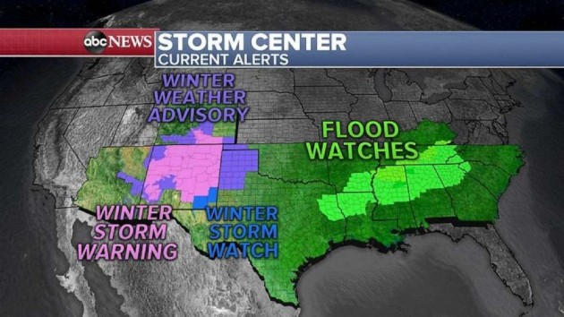
Tuesday morning, snow and flood alerts stretch from Arizona to Kentucky.
Flooding and river flooding is the biggest threat Tuesday morning and into Tuesday afternoon across the South.
Heavy snow of up to a foot is expected in New Mexico with the tail end of this frontal system as the California storm moves east.
By Wednesday, as this system moves further east, a stronger storm will slowly move from the southern Rockies into the Mid-Mississippi Valley with more flooding rain and a threat for damaging winds and a few tornadoes.
To the north, snow will develop from St. Louis to Chicago and into Cleveland.
By Wednesday night into Thursday, the storm moves into the East Coast with snow spreading into the Northeast and heavy rain and thunderstorms possible from Florida to Atlanta into the Carolinas.
Many major cities in the Northeast should see mostly rain Thursday but some areas in northern New Jersey, the Hudson Valley and near Boston could get some snow first, making for a slick morning Thursday.
Copyright © 2020, ABC Audio. All rights reserved.