
 ABC NewsBy MAX GOLEMBO, ABC News
(NEW YORK) — The Gulf Coast is on alert for Sally Monday morning.
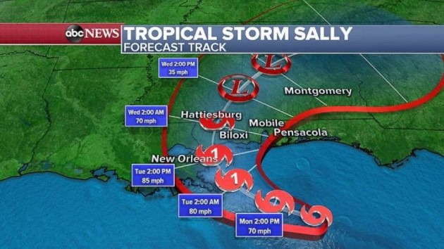
Sally is a tropical storm Monday morning with winds of 60 mph and is about 120 miles east-southeast of the mouth of the Mississippi River.
Sally does not look very symmetrical at the moment with most of the heavy rain and wind on the right side of the storm.
A Hurricane Warning has been issued from Morgan City, Louisiana to the Mississippi and Alabama border.
The latest path takes Sally just near the Mouth of the Mississippi River sometime on Tuesday morning as a Category 1 hurricane but, at this time, it’s hard to say if it will make landfall there.
The storm is expected to slow down and move toward the Mississippi coastline on Tuesday afternoon and then, possibly, make landfall. This could all change depending on how much it slows down and its turn to the north.
Storm surge still remains a big threat even though it will be only a Category 1 storm as it makes landfall.
Because of its slow motion, more water could pile up in the bays and inlets along the Gulf Coast so the storm could seem like it is more than a Category 1 because of that.
Flooding from rainfall is another major threat with Sally because of its slow motion and some areas could see 15 to 20 inches of rain in the next several days with some areas seeing even more than 20 inches.
Elsewhere, Hurricane Paulette is hitting Bermuda now and the island is small enough that it even fits inside Paulette’s eye.
After Monday morning, Paulette will move quickly away from the island of Bermuda and not threaten any land.
Elsewhere in the tropics, we have a new tropical storm and its name is Teddy.
Teddy is forecast to become a major hurricane by this weekend as it moves in the general direction of Bermuda but it is too early to say if Bermuda will get hit again.
Copyright © 2020, ABC Audio. All rights reserved.