
 iStock(NEW YORK) — Two major storm systems are beginning to impact the U.S. this week as the weather pattern turns very active and turbulent.
This morning, alerts from these storms stretch from the West Coast all the way to New York covering 26 states.
These two storms are going to bring just about everything from powerful damaging winds, to very heavy snowfall, to flash floods and other severe weather including the threat of possible tornadoes. Over 100 Million Americans are currently under alert for these two storms.
This morning the first storm is underway in parts of the high plains with heavy snow falling across the Denver Metro area.
Snowfall rates of up to 3 inches per hour is likely through the morning hour with gusts to 40 mph possible. Denver could see up to 14 inches of snow from this storm.
This storm will move off to the Midwest later today, sliding the snow shield from Kansas to Wisconsin. Minneapolis could see locally over 6 inches of snow, with wind gusts of 35 mph tonight into Wednesday.
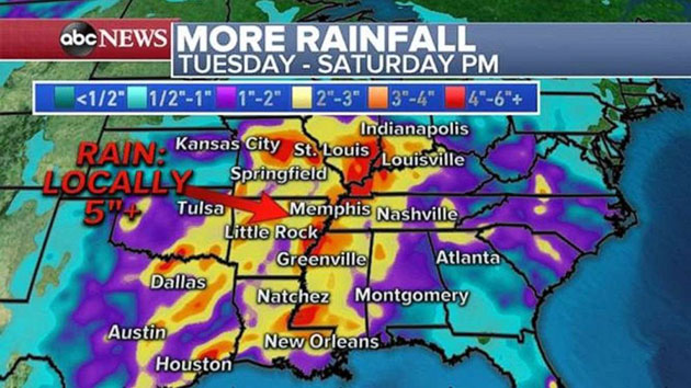
Along the warmer side of the storm, severe storms are likely to develop Tuesday evening across the Mississippi River Valley and into parts of Illinois and Missouri. Damaging winds, large hail and tornadoes will be possible Tuesday night in this region.
By Thursday, this storm should quickly exit the U.S. However, as the storm quickly moves through the Northeast, the main impact will be wind. Wind gusts could be locally over 35 mph Wednesday night and Thursday morning, which could cause problems for the Macy’s Thanksgiving Day Parade.
The second storm will arrive on the West Coast later on Tuesday. This storm looks like it will rapidly intensify as it approaches the western U.S., undergoing Bombogenesis.
30-foot waves will be possible along the northern California and Southern Oregon coast as the storm comes close to the shoreline.
Wind gusts later today in Northern California and southern Oregon could exceed 80 mph which could cause power outages, downed trees and some damage to structures.
Through Wednesday, locally 1 to 3 feet of snow is possible in the Sierras and northern California mountains.
On Wednesday, heavy rain will move into the Los Angeles area with locally 1 to 2 inches possible. This could cause flash flooding in the urban areas of Los Angeles.
In the Southern California Mountains, locally 1 to 3 feet of snow will be possible.
Unfortunately, this storm will track across the country through the end of the week. By Friday it will become another major storm for the central U.S. including the possibility of heavy snowfall across the Rockies likely moving to the Midwest this weekend and significant severe weather in part of the Southern Plains.
Copyright © 2019, ABC Radio. All rights reserved.