
 ABC NewsBy MAX GOLEMBO, ABC News
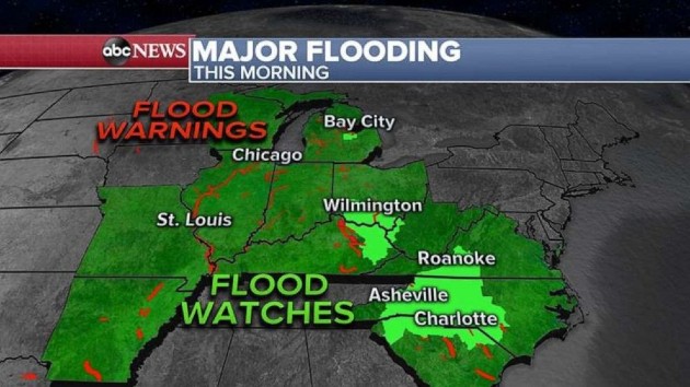
(NEW YORK) — In just 48 hours, parts of Mid-Michigan got hit with more than 8 inches of rain forcing local rivers to record levels, bursting dams and producing catastrophic flooding.
Tittabawassee River rose so high that the Sanford and Edenville dams failed causing flooding to towns further downstream.
Secord and Smallwood dams have high water flow and are also being watched closely Wednesday morning for possible overflow.
Also, the Illinois River in Illinois is in major flooding at the moment and some parts of the river are continuing to rise.
Finally, the same storm system also brought more than a half a foot of rain Tuesday to western North Carolina where flash flooding was reported.
Take a look at all the red spots on the map above — these are all flood warnings on rivers and streams in the Midwest and parts of the South, from Arkansas to Michigan and down to the Carolinas.
A Flood Watch continues from Ohio to the Carolinas Wednesday morning.
The stubborn storm system that brought all the rain to the Great Lakes will slowly slide southeast over the next few days and heavy rain is expected for the Carolinas and Virginia where flash flooding is possible.
Meanwhile, a new storm system is hitting the West and western Plains with severe weather and snow.
On Wednesday, severe weather will stretch from Montana down to Texas with damaging winds and huge hail being the biggest threat and an isolated tornado cannot be ruled out.
In addition, up to 14 inches of snow will be possible in the Rockies over the next 48 hours.
Also, in parts of Idaho, Washington and Oregon, up to 2 inches of additional rain could fall and produce flooding. A Flood Watch has been issued for the area.
Copyright © 2020, ABC Audio. All rights reserved.