
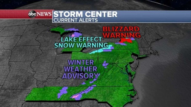
 ABC News(NEW YORK) — Lake effect snow with blizzard conditions will continue in Western New York Friday as a blizzard warning continues north of Syracuse.
The highest snowfall total so far is south of Buffalo in Springville, New York, where 13.5 inches fell. North of Syracuse in Redfield, New York, 13 inches of snow has accumulated and it’s still snowing. That area is also under a blizzard warning Friday.
Snow alerts continue for nine states Friday morning, from Michigan to Tennessee and north to New York.
The heaviest snow over the next 24 hours will be in Western New York and north of Syracuse, where an additional 1 to 2 feet of snow is expected. In Buffalo, 6 to 12 inches are possible there.
With the additional snowfall, areas north of Syracuse will have 3 to 4 feet of snow.
Friday morning, the cold air and wind are causing wind chills to dip into the teens from New York City to Boston with near zero temperatures around the Great Lakes.
Another cold day is expected Saturday in the Northeast and then a significant warm-up is on the way. Temperatures are expected to be in the 50s and even 60s for most of the region early next week. Officially, meteorological and climatological Spring begins this Sunday, March 1.
Moving west, a strong storm system is heading toward the Pacific Northwest Friday with heavy snow for the mountains and rain along the coast.
This storm will dip south into Southern California this weekend with rain for Los Angeles and snow for the southern California mountains.
A winter storm watch has already been issued for parts of the Rocky Mountains where up to 2 feet of snow is expected through this weekend and into early next week.
Copyright © 2020, ABC Audio. All rights reserved.